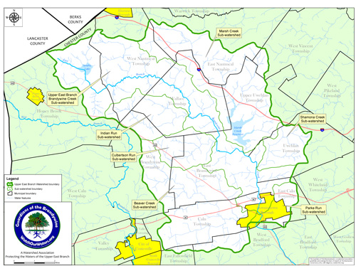
Map of the Upper East Branch of the Brandywine

The map is provided by the Brandywine Conservancy. Click on this PDF link to download an expandable version of the map so you can zoom in to get a closer look.
A collection of educational tools for water resources
Stormwater Outreach Materials and Reference Documents
Nonpoint Source (NPS) Outreach Toolbox
Public Education and Outreach on Stormwater Impacts
DRN Municipal Guide for Writing Ordinances for the Protection of our Water and Natural Resources
Chester County Planning Commission's Letter on Wallace Township's PCCC 1323
DRK Municipal Guide for Writing Ordinances for the Protection of our Water and Natural Resources
A Legal Analysis of Riparian Buffer Ordinances in PA
by Matt Royer
Center for Watershed Protection
Upper East Branch, Brandywine Creek Watershed Conservation Plan
Maps - correspond to those referenced in conservation plan (above)
| Map 1 - Base Map | Map 2 - 1995 Land Use |
| Map 3 - Topography | Map 4 - Elevation |
| Map 5 - Surface Geology | Map 6 - Soils |
| Map 7 - Water Resources | Map 8 - Water Withdrawals & Discharges |
| Map 9 - Forest Habitats | Map 10 - Recreational Resources & Protected Lands |
| Map 11 - Water Resources Conservation Priorities | Map 12 - Riparian Buffers |
| Map 13 - Agricultural Preservation Priorities | Map 14 - Forest Hubs & Corridors |
Wallace Township
Map of Wallace's Habitat Corridors
Map of Wallace's Woodland Classification
Map of Wallace's Exceptional Natural Areas & Rare Plant Species Sites
Map of Wallace's Exceptional Natural Areas & Rare Species Sites (very long download)
Transcript of Thomas Comitta's Testimony Given on March 31, 2009 to the Wallace Township BoS (Thomas Comitta is President of Thomas Comitta Associates, Inc. Town Planner and Landscape Architects)


